

Bora Bora - Wikipedia
source link: https://en.wikipedia.org/wiki/Bora_Bora
Go to the source link to view the article. You can view the picture content, updated content and better typesetting reading experience. If the link is broken, please click the button below to view the snapshot at that time.
Bora Bora
Bora Bora (French: Bora-Bora; Tahitian: Pora Pora) is an island group in the Leeward Islands. The Leeward Islands comprise the western part of the Society Islands of French Polynesia, which is an overseas collectivity of the French Republic in the Pacific Ocean. Bora Bora has a total land area of 30.55 km2 (12 sq mi). The main island, located about 230 kilometres (143 miles) northwest of Papeete, is surrounded by a lagoon and a barrier reef. In the center of the island are the remnants of an extinct volcano, rising to two peaks, Mount Pahia and Mount Otemanu; the highest point is at 727 metres (2,385 feet). Bora Bora is part of the Commune of Bora-Bora, which also includes the atoll of Tūpai. The languages spoken in Bora Bora are Tahitian and French. However, due to the high tourism population, many natives of Bora Bora have learned to speak English.[2]
Bora Bora is a major international tourist destination, famous for its seaside (and even offshore) luxury resorts. The major settlement, Vaitape, is on the western side of the main island, opposite the main channel leading into the lagoon. Produce of the island is mostly limited to what can be obtained from the sea and from the plentiful coconut trees, which were historically of economic importance for the production of copra.
Name[edit]
In ancient times the island was called Pora pora mai te pora, meaning "created by the gods" in the local Tahitian dialect. This was often abbreviated Pora Pora meaning simply "first born". The Tahitian language and the English, French, or Dutch languages, each use a unique set of phonemes, so the spelling and pronunciation of the name changes as it passes from one language to another. Since Tahitian does not distinguish between the sounds [p] and [b], the sound represented by ⟨p⟩ lies in between the two[citation needed], while ⟨r⟩ represents a sound not present in English similar in sound to [l] and [ɹ̠]. So Pora Pora could also be heard by English, French, or Dutch speakers as Bola Bola or Bora Bora. When explorer Jacob Roggeveen first landed on the island, he and his crew adopted the name Bora Bora, which has stood ever since.[3][4]
History[edit]
The island was inhabited by Polynesian settlers around the 4th century[citation needed] The first European sighting was made by Jakob Roggeveen in 1722.
James Cook sighted the island on 29 July 1769, with the help of a Tahitian navigator, Tupaia.[5] The London Missionary Society arrived in 1820 and founded a Protestant church in 1890. Bora Bora was an independent kingdom until 1888, when the French annexed the island as a colony and forced its last queen, Teriimaevarua III, to abdicate.
World War II[edit]
During World War II, the United States chose Bora Bora as a South Pacific military supply base, and constructed an oil depot, an airstrip, a seaplane base, and defensive fortifications. The base, known as "Operation Bobcat", comprised nine ships, 20,000 tons of equipment, and nearly 7,000 soldiers.
At least eight 7-inch guns were operated by some members of the 13th Coast Artillery Regiment (later renamed the 276th Coast Artillery Battalion). The guns were set up at strategic points around the island to protect it against potential military attack. Eight of these guns remain in the area to this day.[6][7]
However, the island saw no combat. The American presence on Bora Bora went uncontested for the entire course of the war. The base was officially closed on 2 June 1946. The World War II airstrip was never enlarged to accommodate large aircraft, but it was nonetheless French Polynesia's only international airport until 1960, when Faa'a International Airport opened next to Papeete, Tahiti.[8]
Tourism[edit]
The island's economy is driven almost entirely by tourism. Several resorts have been built on the motu surrounding the lagoon. (Motu is a Tahitian word meaning “small islands.”) Hotel Bora Bora opened in 1961, and nine years later the first over-water bungalows on stilts over the lagoon were built.[9] Today, over-water bungalows are a standard feature of most Bora Bora resorts. The bungalows range from relatively inexpensive basic accommodations to very luxurious expensive ones.
Most of the tourist destinations are sea-oriented; however, there are also tourist attractions on land, such as World War II cannons. Air Tahiti operates five or six flights daily between Tahiti and the Bora Bora Airport on Motu Mute (as well as occasional flights to and from other islands). There is no public transport on the island, so rental cars and bicycles are the recommended means of transport. In addition, there are small, two-seater buggies for hire in Vaitape, and motorboats can be rented to explore the lagoon. Vaitape is a large city on the west side of the island and is home to a large part of the island’s population. The city has also become a popular spot for tourism.[10]
Snorkeling and scuba diving in and around Bora Bora’s lagoon are popular activities. Many species of sharks and rays inhabit the surrounding waters. A few dive operators on the island offer manta-ray dives and shark-feeding dives. (The species of shark living in the island's lagoon are not considered dangerous to people.)[citation needed]
In addition to the existing islands of Bora Bora, the artificial island of Motu Marfo has been added in the northeastern corner of the lagoon at one of the many resorts.[11]
Climate[edit]
Bora Bora has a tropical monsoon climate. Temperatures are relatively consistent throughout the year, with hot days and warm nights. The dry season lasts from June to October, but there is some precipitation even during those months.
hideClimate data for Bora-Bora Month
Jan
Feb
Mar
Apr
May
Jun
Jul
Aug
Sep
Oct
Nov
Dec
Year Average high °C (°F)
30.2
(86.4)
30.8
(87.4)
30.5
(86.9)
30.3
(86.5)
29.5
(85.1)
28.5
(83.3)
28.1
(82.6)
28.1
(82.6)
28.6
(83.5)
29.1
(84.4)
29.4
(84.9)
29.6
(85.3)
29.4
(84.9)
Average low °C (°F)
25.1
(77.2)
25.3
(77.5)
25.5
(77.9)
25.5
(77.9)
25.2
(77.4)
24.2
(75.6)
23.8
(74.8)
23.8
(74.8)
24.0
(75.2)
24.3
(75.7)
24.6
(76.3)
24.8
(76.6)
24.7
(76.5)
Average rainfall mm (inches)
268.7
(10.58)
233.2
(9.18)
176.9
(6.96)
182.7
(7.19)
129.8
(5.11)
98.2
(3.87)
83.3
(3.28)
59.7
(2.35)
65.5
(2.58)
99.8
(3.93)
203.7
(8.02)
280.6
(11.05)
1,882.1
(74.10)
Mean monthly sunshine hours
201.1
202.6
239.4
219.8
224.1
224.5
231.8
248.4
241.0
230.5
217.7
207.0
[13] Most rainfall occurs during the summer months (November to April) and is accompanied by high humidity, although clear days are not unknown in mid-January.[citation needed]
Endemic gastropod ecology and decline[edit]
Historically, Bora Bora’s virgin forest habitats, on the slopes of Mount Otemanu, had a very diverse assortment of snail and slug species (gastropods) compared to other islands. Several species of endemic or native species existed in great numbers until relatively recently. However, after Lissachatina, Euglandina and various flatworms were introduced to the island, they had wiped out the populations of the endemic partulid species Partula lutea the late 1990s),[14]Samoana attenuata (a species once native to Bora Bora but later not found in surveys of the island[14]), and Mautodontha boraborensis (a critically endangered species as of 1996 but most likely extinct, as it was last seen in the 1880s[14]). The above listed native and endemic species were mostly restricted to virgin forest, and the only species that remain common (perhaps even extant) are several subulinids and tornatellinids among others, including Orobophana pacifica (a helicinid).[15]
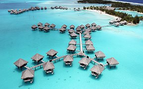
Gallery[edit]

Aerial view of Bora Bora

Aerial view of Bora Bora

Mount Otemanu

The French frigate Floréal, stationed in Bora-Bora lagoon
Maohi Protestant Church in Anau
Coca-Cola Machine in Vaitape

Leaning palm trees with metal bands to stop coconut crabs
Sofitel Motu with Mount Otemanu in the background
Bora Bora

North-east view of Bora Bora from Mt Pahia

Looking east toward Marara Beach Motu in Bora Bora
Bora Bora
Satellite image of Bora Bora
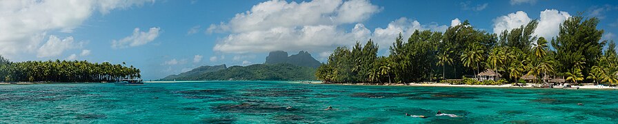
Panoramic image of Bora Bora


See also[edit]
References[edit]
- ^ "Populations légales de Polynésie française en 2017" [Legal Populations of French Polynesia in 2017]. Insee (in French). 27 December 2017. Retrieved 13 January 2018.
- ^ "French Polynesia - The World Factbook". www.cia.gov. Retrieved 4 March 2021.
- ^ Woods, Michael; Woods, Mary B. (2009). Seven Natural Wonders of Australia and Oceania. Twenty-First Century Books. p. 58. ISBN 978-082-259074-3.
- ^ "An Ancient Wonder — Bora Bora Island". Must Do Travels. 11 January 2017. Archived from the original on 22 January 2017. Retrieved 13 January 2018.
- ^ Salmond, Anne (2010). Aphrodite's Island. Berkeley: University of California Press. pp. 213–214. ISBN 978-052-026114-3.
- ^ Gaines, William C. (May 2009). "Coast Artillery Organizational History, 1917-1950 — Part I, Coast Artillery Regiments 1-196" (PDF). The Coast Defense Journal. p. 10.
- ^ Berhow, Mark A., ed. (2015). American Seacoast Defenses, A Reference Guide, Third Edition. McLean, Virginia: CDSG Press. p. 235. ISBN 978-0-9748167-3-9.
- ^ "Contenu et images Notre histoire" [Content and Images Our Story] (in French). l'Office des Postes et des Télécommunications [Office of Post and Telecommunications]. Archived from the original on 13 April 2013. Retrieved 18 April 2011.
- ^ Mark Rogers (22 July 2008). "Complete Reconstruction Scheduled for Hotel Bora Bora". Travel Agent Central. Archived from the original on 16 February 2015. Retrieved 15 February 2015.
- ^ "Bora Bora". www.adventure-life.com. Retrieved 4 March 2021.
- ^ "Motu Marfo". All About Islands. Retrieved 22 July 2021.
- ^ "Bora-Bora Motu Climate Normals 1961–1990". National Oceanic and Atmospheric Administration. Retrieved 13 January 2018.
- ^ "Climate and average monthly weather in Bora Bora (Bora Bora), French Polynesia". weather-and-climate.com. Retrieved 14 February 2019.
- ^ Jump up to: a b c "The IUCN Red List of Threatened Species". IUCN Red List of Threatened Species. Retrieved 28 December 2018.
- ^ Gerlach, Justin (August 2017). "Partula survival in 2017, a survey of the Society islands" (PDF). Island Biodiversity. Retrieved 28 December 2018.
External links[edit]
Recommend
About Joyk
Aggregate valuable and interesting links.
Joyk means Joy of geeK