

You Can Find Military Radars On Publicly-Available Satellite Data
source link: https://hackaday.com/2022/03/02/you-can-find-military-radars-on-publicly-available-satellite-data/
Go to the source link to view the article. You can view the picture content, updated content and better typesetting reading experience. If the link is broken, please click the button below to view the snapshot at that time.
You Can Find Military Radars On Publicly-Available Satellite Data
When it comes to hunting down military radar installations and associated hardware, we typically think of equipment that is firmly in the price bracket of nation states and their military forces. Whether it’s early warning radar, those used for air defence, or for naval purposes, you’d think it was relatively difficult to intercept or track these emissions.
However, a new tool built by geocomputation lecturer Ollie Ballinger shows this isn’t the case. In fact, openly-available data captured via satellite can be used to find all manner of military radar emitters. Let’s explore how!
Open Data Reveals Surprising Things
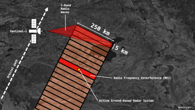 A diagram indicating how interference from military radars shows up on SAR satellite images. Credit: Ollie Ballinger, used with permission
The discovery that openly-available satellite data could reveal the locations of military radars came from the work of Harel Dan, a geospatial engineer from Israel. Dan was looking at data captured by the synthetic aperture radar of the European Space Agency’s Sentinel satellites. After accidentally maximising the display of noise and interference on the synthetic images, he noticed strange bands appearing in various spots in the Middle East, and investigation into the cause began.
The Sentinel-1A and Sentinel-1B satellites, operated by the European Space Agency (ESA), carry synthetic aperture radar (SAR) instruments operating in the C-band, the spectrum taking in frequencies from 4.0 to 8.0 GHz. The SAR essentially uses the motion of the spacecraft to create a large “synthetic” antenna aperture for capturing radar images of the ground. The technique allows the SAR to image the ground as if it had a much larger antenna than it actually does, thanks to the spacecraft’s motion. It gives the SAR a far higher spatial resolution than is possible using a traditional scanning beam radar.
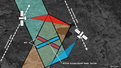 SAR images captured from two satellites can be overlaid to narrow the area in which a interfering radar emitter could be located. Credit: Ollie Ballinger, used with permission
The SAR imaging systems on board the Sentinel satellites operate within the same frequency range as many military radars. As the satellites passed overhead, sending out radar signals to the ground and picking up the returns, they were also picking up emissions from military radar systems, which were showing up as bright blue and red bands on the SAR radar pictures.
As it turns out, Dan was seeing interference caused by MIM-104 Patriot PAC-2 aerial defence systems installed in various Middle Eastern states. Given that the ESA makes all data from the Sentinel satellites publicly available, this meant that anyone with a mind to delve into the data could see this interference as well.
The Sentinel satellites typically operate in a mode where they image strips of land 250 km long and 5 km wide with their radar apparatus. When a military radar system is in operation in one such swathe of land, it creates a bright streak across the entire 250 km x 5 km strip. When images from Sentinel-1A and Sentinel-1B are overlaid, it’s possible to see a point where two stripes affected by interference cross each other. This can narrow down the area in which the radar system could be located – in the overlap between the two interference stripes.
 Interference bands caused by radar systems in Sweden. Source: Radar Interference Tracker
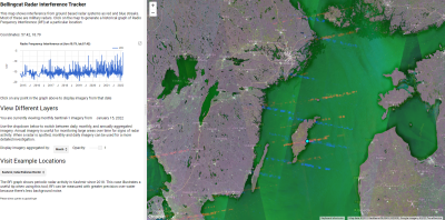
Armed with the knowledge of this phenomena, Ollie Ballinger set about building a tool to more easily allow researchers to look for radars using publicly-available data from the Sentinel-1 satellites – the Radar Interference Tracker (RIT). It can reveal interference picked up from a wide range of military radars, from US-built Patriot systems, to the Japanese FCS-3, Chinese Type-381, and even the Russian S-400 surface-to-air missile system. If these systems have their radar switched on when a Sentinel-1 satellite passes overhead, they should be visible on the RIT.
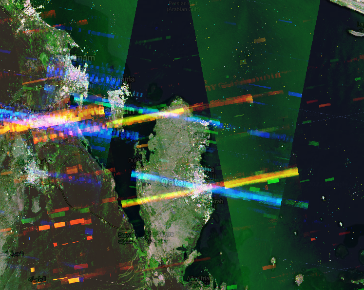 A particularly strong interference band is readily visible in Qatar. Source: Radar Interference Tracker
The tool lets users look at data from given points in time, helping researchers find out when and where military radar systems were switched on. Graphs of interference picked up by the satellites over time help find relevant time periods quickly.
It bears noting that the RIT is not a conclusive intelligence tool all on its own. Often, interference found on these images must be corroborated with other optical satellite imaging data or other intelligence reports to confirm movements of military hardware. A further issue is that the satellites take several days to revisit a given area; if a radar is turned on and back off in between satellite passes, it won’t show up in the data. However, the RIT can still prove useful for quickly identifying areas of interest with regards to military radar hardware.
It’s great to see the ESA sharing satellite data for anyone to use, and it’s also wonderful to see open-source tools improving what can be done with said data. Those interested in the RIT can even dive into the code themselves on Github. It goes to show what can be done by the broader community when information is made available to all!
(Editor’s Note: This article was conceived and written before Russia’s invasion of Ukraine.)
Recommend
About Joyk
Aggregate valuable and interesting links.
Joyk means Joy of geeK